
Seen
Once you have covered at least 1% of a street, it appears in your collection and on the map.
 Katujahti
LEARN THE GAME
Walk the streets. Watch your map fill in.
Choose a municipality, tap Start collecting! and head out. Katujahti recognizes the street, counts the sections you cover and shows what is still waiting to be discovered around the city.
Get started in a minuteUpdated 9 September 2026. Changes in version 2.0 are marked separately.
Some guide images show earlier versions of the game. Version 2.0 changes are marked in the text.
YOUR FIRST OUTING
The heart of the game is simple. These three steps will get you started.
Choose a municipality by location or name. Download its data before heading out if you plan to play without a connection.
Walk, jog or run. The game recognizes the street automatically. You do not need to select or check off streets, and no account is required.
The summary shows new street coverage, Captured and Mastered streets, XP, challenges, Street Level increases and achievements.
MAP AND STREETS
A street fills up through small coverage points. The same spot only adds progress once, but you can continue an unfinished street whenever you like.
Once you have covered at least 1% of a street, it appears in your collection and on the map.
You have covered a quarter of the street. This is where the street hunt truly begins.
You have covered virtually the whole street. A small margin accounts for GPS inaccuracies and inaccessible ends.
Each street is divided into coverage points about 10 metres apart. Going back and forth does not fill the same point again.
You see the detected street, its progress, GPS status, the compass and the Finish button. The map follows your location. Re-centre resumes tracking if you have moved the map by hand.
Choose from walking time, total time, distance, average pace, average speed, GPS status, new street coverage, Captured, Mastered, unique streets, distance to the next threshold, unique areas, unique municipalities, daily goal, Daily Challenge and Street Bingo.

NOT THE SAME AS COVERAGE
Coverage shows how much of the street you have walked. Street Level rises through accepted visits.
From version 2.0, a visit counts when you walk 60 metres of a street, or the whole street if it is shorter. Only one visit to the same street counts per outing. The next visit can be accepted no sooner than 45 minutes later. Capturing a street still depends on the proportion you have covered.
FROM VERSION 2.0
Side Paths covers paths and walking and cycling routes that are separate from the street network. Turn it on when you want to collect more than streets.
Open Settings → Playing and appearance. Choose Streets only or Streets + Side Paths. The choice stays the same throughout the outing.
Side Paths has its own Seen, Captured and Mastered states and statistics. It does not increase street completion in a municipality.
A pavement or cycling route beside a street is not turned into a second collectible. Side Paths are routes separate from the street network.
Other routes is a separate map layer for planning. Showing it does not turn on Side Paths collection.
MUNICIPALITIES AND AREAS
Each municipality is its own playing field. You can switch municipalities at any time, download your next destination in advance and continue where you left off in each place.
On the map of Finland, you can find your next municipality. Its card shows the number of playable streets, the street network's approximate length, its coat of arms when available and your own progress. A municipality appears on your My Finland map when you capture your first street there.
The areas are usually Statistics Finland postal code areas, not administrative neighbourhoods. Turku uses the city's official small-area division. An area is Captured or Mastered when all its playable main streets have reached the same status.
A downloaded municipality works without a connection: its streets, map data and base map go with you. Removing the package frees up space but does not erase your progress.
Collect streets in several municipalities during one outing. In settings, keep neighbouring maps ready or allow the next municipality to download while you walk. Without a downloaded map and an internet connection, distance still counts but streets in the new municipality do not. Your summary lists the municipalities you visited.
Along with street progress, the area details show population, area, population density and median age. They may also highlight single-person households, blocks of flats or detached homes, students and living space.
The data describes the area, not the player or individual residents. The statistical year is always shown.
Your personal map of Finland colours the municipalities you discover according to your progress. Each municipality card shows the discovery date when known, Captured and Mastered streets, and your next 25%, 50%, 75% or 100% municipality goal.


STATS
In Stats, you can view one municipality or all of Finland. Changing the scope does not change the active municipality on the game map.

Your Seen, Captured and Mastered streets, level and XP, nearest street milestone, weekly figures and current challenges. At Finland level, you can see your municipality discoveries and nationwide street progress.
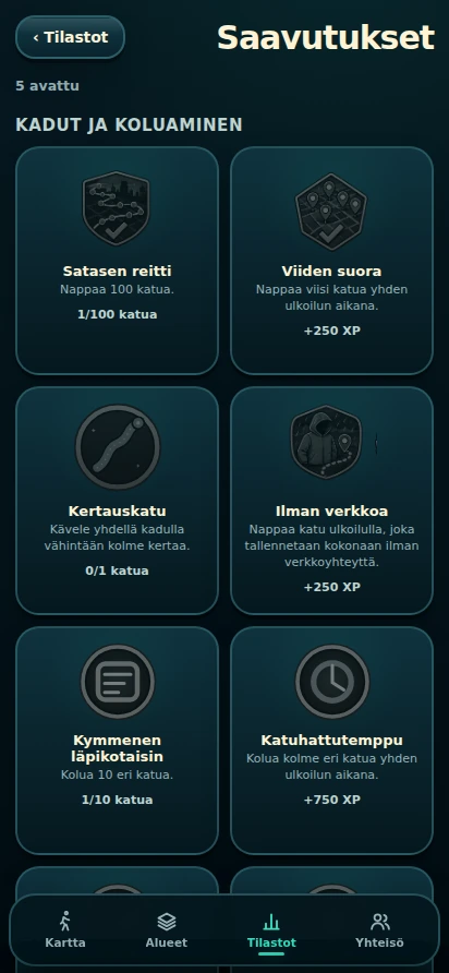
Find your street collection, street cards and achievements here. The Finland view shows the collection of all 308 municipalities. Version 2.0 adds 50 achievement types and clearer groups. Municipality badges appear as you earn them.
Every saved outing from every municipality, newest first and 20 at a time. Days are grouped by the outing's end date. At Finland level, you can filter the list by municipality.
Open an outing to see the accepted route, local street network and street sections in their status colours after the outing. Seen uses a dashed line. The same view shows distance, duration, XP, Captured and Seen streets, plus Share and Export GPX. If map data is missing, you get a simpler route preview.
WHEN YOU WANT TO DIG DEEPER
The activity grid shows new street coverage, not your full walking distance.
OPTIONAL CHALLENGES
Challenges progress during ordinary outings. You do not need to start them separately, and you lose nothing by skipping one.
One clear task, such as capturing a new street, mastering a street, returning to familiar streets or raising a Street Level. The challenge is the same in every municipality. You can swap an unfinished challenge once a day if another suitable task is available; today's saved events are then counted towards the new task.
Tasks: Opening Street, Level Up, Bullseye, Familiar Route, Three in a Row, Return Round and Double Boost.
A 3 × 3 grid that runs from Monday to Sunday and can progress in any municipality. Tasks may involve outings, distance, active days, new streets, return visits, level increases, Mastered streets and municipalities. A horizontal, vertical or diagonal line makes bingo, and 9/9 completes the board. You can swap an unfinished board once a week. Street Bingo does not award XP.
Every completed Daily Challenge adds one stamp to the calendar. An empty day does not remove stamps you have already collected. The book has no streak or success percentage. it shows the days when you completed the challenge.

TOGETHER, IF YOU WANT
The core Katujahti game works without an account. In version 2.0, the sign-in screen also explains Shared Finland participation: signing in enables it if you have not yet made a choice. Previous opt-outs are preserved. You can change participation in settings. Sharing in Groups is a separate choice.

With an account, you can create a private group or join one with an invitation code. Joining does not yet share your stats. In each group, you choose separately whether to share a summary, the shared map or area-specific figures.
Anyone can view the combined map and totals without signing in. Participating requires an account and sends street IDs and statuses into the shared total. Other people do not see your route or street list. You can stop participating at any time.
Rankings are a separate choice from Shared Finland. You choose the nickname and stats used for comparison. Sharing within a group is configured separately in that group's own view.
Finland Together and Groups do not receive your raw GPS route, current location, speed, heading or pictures. Shared street identifiers and states may still show where you have played. You see the sharing options before joining.
MAKE THE GAME YOURS
Choose a municipality, tap Start collecting! and see where your map begins to grow.
KEEP YOUR PROGRESS
From version 2.0, Katujahti's own online backup is removed. The game and your progress remain on your phone. Your account still gives you access to Groups and shared statistics.
From version 2.0, detailed route points from completed outings are kept on your phone for 90 days. Walk history, progress, achievements and statistics remain afterwards. Export any route you want to keep as a GPX file before the period ends. Files you have already exported are not removed by the app.
Your phone may back up Katujahti data to iCloud or Google, depending on your settings. You can change this in your phone settings. What gets backed up and restored depends on your phone and settings.
Export a full file backup from the old phone. It can transfer your progress between the two operating systems too.
If you previously saved a Katujahti backup as a file, you can restore it under Settings → Backup → Restore from file. Contact support if you need help with an older online backup.
Help with backupsA full file backup and your phone's backup may include precise GPS routes. Choose where you keep them. Katujahti does not send them to its own servers.